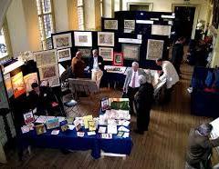
Over 40 leading map dealers as well as hundreds of visiting collectors, curators and map aficionados from all parts of the world will gather at The Royal Geographical Society bringing an unparalleled array of original antique maps, charts, town plans, atlases and globes. Thousands of maps covering all parts of the world and every era of map-making will be on display, from the 15th century to the present day. A veritable treasure trove, the fair gives collectors the chance to pick up some exceptional and beautiful pieces without necessarily having to spend a fortune as there’s something for everyone; prices range from £10 to hundreds of thousands. Many visitors also come to find maps to give as unique and memorable presents. Some of the items on sale this year include:
A beautiful signed and hand-coloured 1815 first edition of William ‘Strata’ Smith’s ‘Delineation of the Strata of England and Wales, with Part of Scotland’ - the first large-scale, detailed scientific geological map of any country, and the subject of Simon Winchester's bestselling book 'The Map that Changed the World'.
William Faden larger version of the Richard Horwood’s survey of London; the most important map of Georgian capital in the 1790s. Published in 1819, revised and extended to include the new docks in the east end. This version of the map was printed in 40 sheets and measures over 2 metres by 5 metres.
Or for the Battle of Waterloo enthusiasts: an opportunity to purchase a rare broadsheet plan of Waterloo and the environs of the battlefield made by an anonymous British army officer who was at the Battle.
This year’s Guest Speakers will be map-seller, Tim Bryars and Tom Harper, the British Library’s curator of antiquarian mapping.
Tim and his co-author Tom will be discussing their recently published British Library bestseller A History of the 20th Century in 100 Maps, revealing how maps permeated almost every aspect of daily life in the last century:
‘From the Beatles to the Bomb, from top-secret documents to mass propaganda, maps tell many stories, allowing us to explore changing social attitudes towards the unfamiliar and unconventional, from Jewish London at the turn of the century to women in the workplace, and from the Edwardian opium trade to gay London in the 1980s.’
London Map Fair 2015
Royal Geographical Society, 1 Kensington Gore, London
Ad
Event has ended
This event ended on Sunday 7th of June 2015
This event ended on Sunday 7th of June 2015
Admission
Free
Free
Website
Tags:
Art
User Reviews
There are no user reviews