This event was originally scheduled for 6 August but has been moved due to the planned London Underground industrial action - we apologise for any inconvenience caused.
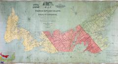
Samuel Holland's 1765 map of Prince Edward Island was the first accurate map created of the island, situated just off the Nova Scotia coast. This summer this enormous map is being loaned to the island and it will feature in a major exhibition at the Confederation Centre Art Gallery in Charlottetown.
This fascinating talk by one of our conservation experts will use photos and film clips to show the painstaking process of conserving this huge map, the challenges associated with preparing such an object for an exhibition and its transatlantic journey to get there.
Samuel Holland’s Map
The National Archives, Kew, Richmond, Surrey
Ad
Event has ended
This event ended on Thursday 3rd of September 2015
This event ended on Thursday 3rd of September 2015
Admission
Free
Free
Location
The National Archives, Kew, Richmond, Surrey
Tags:
Workshops
User Reviews
There are no user reviews